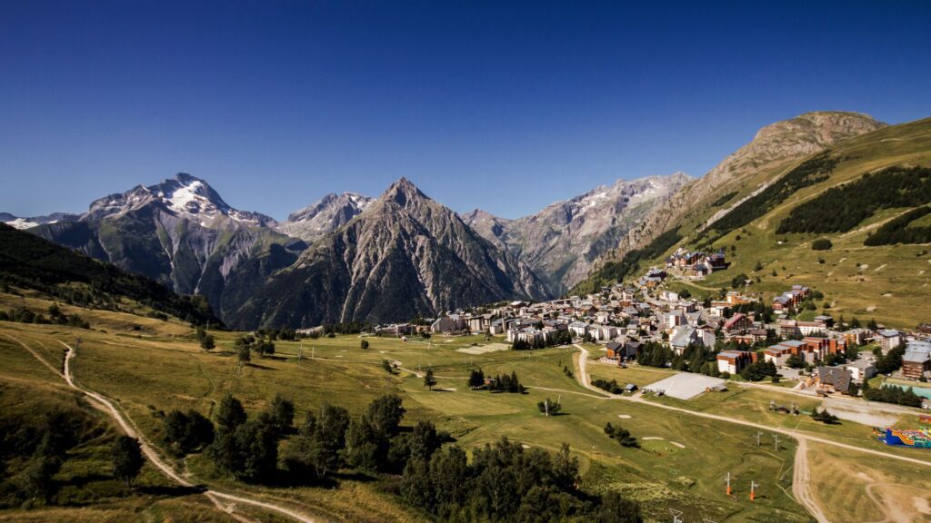
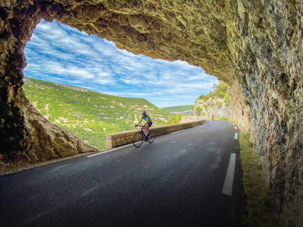
With the name comes images of cycling greats battling each other while ascending the 21 switchbacks to the village of Alpe d’Huez.
The climb itself is 13.8km long at an average gradient of 8.1%, gaining 1135m of climbing. Each switchback has a plaque counting down the turns so you don’t forget, while offering inspiration of previous tour winners and their year. There are two podiums to showcase your feat of ascending the Alpe, one is in the town, and the other is at the official finish line of the Tour de France. Our route will take us on a similiar path as the 100th of Edition of the tour in 2013 tour, which ascended the Col de Sarenne. This Col is little known, but offers the cyclist stunning views of La Meije, Les Deux Alpes, and the surrounding Haute Alpes. The descent to the Lac du Chambon is stunning, and we pass through stunning villages. Once at the Lac we have one more climb back to the village of Les Deux Alpes.
What you need to know
RIDE DETAILS While climbing Alpe d’Huez is every cyclists dream, in the summer time, the village of Alpe d’Huez is extremely busy with tourists, and the road is usually full with cyclists and vehicles.
WEATHER During the summer months, it is best to tackle Alpe d’Huez earlier in the day versus later in the day. The combination between high temperatures and late afternoon thunderstorms can make the ascent a true adventure. If you are wanting to tackle Alpe d’Huez to see your fastest time, it is best to experience it the first time at a comfortable pace and to take in the views, the switchbacks, and the crowds. This will allow you to understand the climb better, along with knowing where the finish of the Tour de France line is located. Then, your second attempt, if you are going for your Personal Record, you are able to really go for it!
FUEL There are numerous places to refuel on today’s ride, but it is best to refuel before you begin your ascent of the Alpe. Once on top of Alpe d’Huez, it is another great time to refuel. There are limited services between Alpe d’Huez and Mizoën.
While you’re in town
At the finish line of the in the village of Alpe d’Huez is the Trek Store. This is one of our favorite locations to purchase an Alpe d’Huez cycling kit, and or some form of memorabilia reminding you of your famous ascent. At times, they have medals that you can purchase to remind you of your climb.
In Alpe d’Huez Tourism office, one is able to purchase a certificate that you can have officially stamped to show your time up Alpe d’Huez. It is a great way to immortalize your ascent up this famous climb!
If cycling back up to Les Deux Alpes is not for you. After your ascent up Alpe d’Huez and the Col de Sarenne, you could descend back to the valley floor, make a left onto the D 530 to Venosc and then for a few Euro’s, you can take a ride in the Telecabin back to Les Deux Alpes. It is a great way to achieve longer descent, with less uphill effort.
Ready for for this ride?
Book early and save. We reward our guests with lower pricing and more dates to choose from the earlier you book. Rest Assured, once you book, your price is guaranteed.
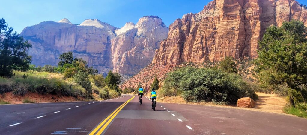
Zion canyon was officially dedicated as a National Park in 1919 and boasts some of the most dramatic sandstone canyons, raging rivers and unique wildlife in the country.
This ride will take you along the flash-flood prone virgin river as you wind through Zion canyon surrounded by 3,000ft sandstone walls. The canyon walls will narrow and cottonwood trees will line the road as you approach the end of the bikeable terrain at the Temple of Sinawava where you can peak your head toward the iconic river hike, The Narrows, which takes you further up the canyon. This truly unique experience is not one to miss! Cyclists will have to pay a $20 per person fee upon entering the park. This pass will be good for 7 days of re-entry so you can keep coming back to explore all Zion canyon has to offer. The pavement through the canyon is excellent making it great for all types of bikes. It should be noted, though, that electric bikes are not allowed in the park or on park paths.
What you need to know
RIDE DETAILS While it is net uphill from Springdale to Temple of Sinawava, the grade is mellow and comfortable. You’ll want to go slowly to bask in the impressive and awe inspiring canyon, anyway. Take a bike lock and hiking shoes with you and stop at one of the many trailheads throughout the canyon to further explore this national treasure.
WEATHER Fall and spring are the best times to visit the canyon when the temperature is more moderate and fewer people visit the park. Summer months can be very busy, extremely hot and have a high risk of encountering a flash flood. Winter months are very cold and sometimes icy or snowy. The massive canyon walls block the low winter sun and the road rarely sees sunlight in the winter therefore, is far colder than outside the canyon.
FUEL Once in the canyon, there are several spots to fill water and about half way into the ride you can stop at Zion lodge to purchase snacks, souvenirs or have an ice cream cone (except for winter months).
While you’re in town
Springdale has several excellent restaurants, galleries and shops. Don’t miss the opportunity to explore town as the sun sets over the canyon walls or enjoy a drink on one of the many patios in town as the stars come out.Springdale has several excellent restaurants, galleries and shops. Don’t miss the opportunity to explore town as the sun sets over the canyon walls or enjoy a drink on one of the many patios in town as the stars come out.
There are several non-biking options for activities in Zion National Park, everything from hiking to backpacking to canyoneering to climbing. The many outfitters in town will get you set up with a guide and the proper gear to prepare for your adventure.
While Springdale is quite small, there are several lodging options. From larger chains to small bed and breakfasts or national park campsites. These generally fill up far in advance during high season so book in advance! In the event that Springdale is booked out, there are plenty more lodging options 30-45 minutes away in Hurricane and St. George.
Ready for this ride?
Book early and save. We reward our guests with lower pricing and more dates to choose from the earlier you book. Rest assured, once you book, your price is guaranteed.
A simple spin around the island will reveal this truth. The roads feel like they were designed specifically for the bike.
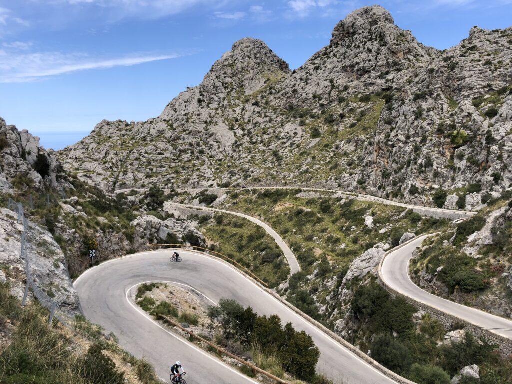
Today’s ride to Sa Calobra is the ultimate descent and ascent on the Island for cyclists. This road was built by local Antonio Parietti Coll, of Italian descent, who wanted to keep the integrity of the landscape. Peter Stuart’s article, “Chasing Perfection” on cycling.co.uk sums the ride up best, “this as close as one could get to a perfect road…” Today’s ride begins with an amazing 28km climb at 3% past the Lluc Monastery. As we leave the small villages of Mallorca and climb into the Tramunta Mountains, the sweeping switchbacks, views of the mediterranean, and the quality of pavement leave you in a state of awe. Upon reach the top of our climb, we find ourselves at the Coll de Cal Reis, 682 m.a.s.l.. The next 9.5km is a descent at 7% average to the village of Sa Calobra. This part of the ride is the cyclists dream. Sweeping switchbacks, views, changing topography, and a 270* spiral bridge known as the “Tie Knot.” After enjoying the sea, having a drink, we tackle the climb back up to the col. The next 50km from the top of Sa Calobra will leave you with a -1.6% ride taking you back to the hotel. If there is one ride that you must do in your life, this is that ride.
What you need to know
RIDE DETAILS Today’s route is highlighted by Sa Calobra, but the majority of the ride would be a noteworthy in any other country. There are numerous places to refuel along the route. Remember to stop and enjoy the journey today. The descending on today’s route is superb. Be aware of the vehicular traffic while descending to Sa Calobra. At times, the tour busses and cars may become annoying. If this is the case, wait and give them ample time / space. The descents are far more enjoyable when you are not constantly on your brakes.
WEATHER It is best to take layers with you today. The temperature changes due to the elevation gain and loss of the ride, along with cycling in the mountains, can be extreme. Having a light windbreaker or vest will make all the difference.
FUEL There are ample spots to grab food and water on today’s ride. The first being at the Coll de la Batalla just over 16km into the ride. The next is 9km later at a coffee shop sitting below a Roman Aqueduct. Sa Calobra is a great place after your descent to refuel. Then on the remainder of your ride, every 5 to 10km there are spots to refuel, or stop and rest and take in the view.
While you’re in town
Cycling to Sa Calobra and taking the boat back to the Port of Soller is a fantastic option. The beauty of the coast line of Mallorca is stunning. Also, you may want to back a suit in your jersey to jump into the after your descent to the village.
In the village of Sa Calobra, there is a little path that takes you through a tunnel to the Torrent de Pareis. This little passage opens to a stunning beach that feels like it is cut off from society. If you are looking to ride and to get away from the crowds, this is a fantastic place to spend some time and watch the waves break.
Ready for Sa Calobra?
Book early and save. We reward our guests with lower pricing and more dates to choose from the earlier you book. Rest assured, once you book, your price is guaranteed.
For 176km, and almost 3600m of climbing, you can challenge yourself on the same roads of the pros.
This time the route is a loop, beginning and ending in Nice, covering the second stage of what is planned to be the 2020 Tour de France route. A breathtaking stage in the Alpes-Maritimes, the ride features two major mountain passes over 1500m, plus a climb up to Col d’Èze, and some spectacular views of the Mediterranean Sea before crossing the finish line back in Nice.
What you need to know
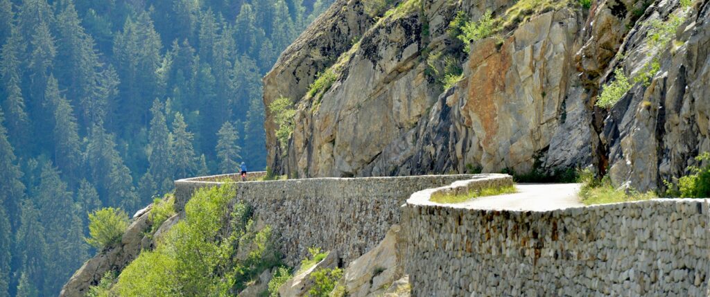
RIDE DETAILS The first section of the ride brings out of Nice on a steady false flat for 55km heading from the sea to the mountains. Please note that this section varies slightly from the official Etape route to run on parallel roads, in the case of riding this route under normal conditions/without road closures. You’ll arrive to your first major climbing challenge, the Col de la Colmiane, also know as Col St Martin, at the 55.6km mark. From here, you’ll be pedalling up for the next 16.3km at an average of 6.3%. The first two km will definitely warm you up if you aren’t already, then enjoy a few sections of respite during the next 9km, plus beautiful views as the road climbs along the gorge in the Vallon de Bramafan, before a steady climb for the final 5km. Enjoy the 20km descent, but take it easy on some of the early tight switchbacks.
WEATHER This region is a popular training ground for many pros due to its great terrain, smooth roads and climate (with over 300 days of sunshine a year). As such, the season for riding here is quite long, but best conditions will be found late spring and early fall. Prepare for serious heat in the summer at lower elevations, and if riding in early spring or late fall, be sure to check on road conditions up high as the Maritime Alps can see good amounts of snow. Prepare for a significant temperature difference along route and bring ample layers with you. It’s easy to see temperatures at least 15-20oC lower on the cols compared to the coast, especially if riding this in shoulder season.
FUEL As you climb the switchbacks of Col de Turini, it’s easy to forget how close you are to the crowds of Nice and the climate of the French Riviera. In fact, this area has long been a tourist destination recommended for its natural spring water and fresh air. Watch for fountains along the route, stating ‘Eau potable’ and fill up your bottles with clear cool water. You should find several places to stop for food and water along route. Notably services are available at: Plan du Var 30km in, La Bolinette at 54km where you’ll find a great little pizzeria/roadside stop (Il Gatto Verde), Saint Martin Vesubie at 78km just after the Col de la Colmiane, la Bollene Vesubie at 91km just before the Col de Turini, and Lucéram at 123km.
While you’re in town
These may actually be some of the lesser known cycling climbs in the region, but what they lack in reputation, they make up for in views and scenery. If you have more time in the region, be sure to also check out the Col de la Madone, Col de Brause, and Madone d’Utelle.
The Col de Turini however may be recognized from the Monte Carlo Rally. Every year in January, racers drive up from La Bollene-Vesubie to the summit and descend down to Sospel. With its many hairpin turns and narrow roadway, it’s generally one of the more technical aspects of the course.
Ready for the Etape du Tour?
Book early and save. We reward our guests with lower pricing and more dates to choose from the earlier you book. Rest assured, once you book, your price is guaranteed.
Tucked in between the iconic Mont Ventoux and the world famous lavender fields, Gorges de La Nesque is yet another feature that makes Provence such a world renowned region.
On this ride you will pedal through the wildly beautiful canyon, below towering limestone cliffs that reach up to 400 meters high in some places.
You will feel as though you are taking a ride back in time as you meander through this quiet and untouched area. Once through the gorge, the beauty of Provence will open up to you as you pedal by countless kilometers of lavender fields (blooming their brightest in mid june!) and through beautiful French villages. Stop for lunch, a coffee and some souvenir shopping in the hilltop village of Sault before the dreamy cruise back down to Villes Sur Auzon.
What you need to know
RIDE DETAILS At 55kms and 850m of elevation gain, this beautiful ride will offer incredible views and not destroy the legs. While trending uphill, through Gorges de la Nesque, the gradients are a mellow 2-4%. There are 4 tunnels through Gorges de La Nesque, none of them are very long but they are quite narrow. It is recommended to at least have a rear light so that cars can see you better.
WEATHER It is usually very windy through Gorges de la Nesque. Leave the aero bikes and deep dish wheels at home unless you like getting blown around!
FUEL There are very few resources while out on this ride. The best location for resupply is half way through the ride in Sault.
While you’re in town
Explore the many Lavender fields and extraordinary lavender products sold at almost every shop in the area. You will see everything from lavender soap to lavender honey and lavender shampoo, stock up on the best lavender in the world while you are here!
There is tons to do in this special region of France. Many amazing rides, famous wineries, open air markets in Gordes and Menerbes, hiking in Gorges de La Nesque and so much more. Plan to spend several days here to experience it all.
Ready for Gorges de la Nesque?
Book early and save. We reward our guests with lower pricing and more dates to choose from the earlier you book. Rest assured, once you book, your price is guaranteed.
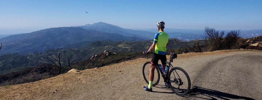
You’ll start by parking at a campground off of San Marcos pass and immediately start climbing and winding your way up to the ridge.
About 11 miles in, the trees will open up and you will start to understand why this is called the “sky road” when you experience the incredible 360 degree views of the pacific ocean, Santa Barbara and the Santa Ynez mountains. On the ridge line, thousands of feet above the ocean, you will experience a dry chaparral landscape that is far different from the lush greenery where the ride started. This rollercoaster of a road will take you higher and higher up into the sky before dropping down every once in a while and allowing your legs to recover and take in the views. While extremely challenging and steep, this southern California gem is unmatched in its views of the surrounding areas and should not be missed!
What you need to know
RIDE DETAILS The first 11.5 miles will be the hardest section where the climbing is relentless and you will see grades of 12%. The middle part of the ride once you are up on the ridge is 30 miles round trip and 3600ft of elevation gain. The maximum grade on this ride is 13.4% and this can be sustained for half a mile in some sections. Be prepared to climb!
WEATHER The temperature up on the ridge can be 10-15 degrees colder than down in Santa Barbara. Be prepared for colder weather and possibility of rain especially in winter and spring. Camino Cielo is also extremely exposed and therefore can be incredibly hot and dry in the summer and fall. Plan your hydration, clothing and sunscreen appropriately during these times. Due to the duelling extremes of very high heat and drought to intense and frequent rain, this road is subject to landslides, washed out sections and debris in the road. Make sure to use caution and check with local bike shops to understand the condition of the road before you go.
FUEL There are no resources at any point on this ride. It is recommended to bring at least 3 16oz bottles of water and plenty of food and supplies to be self supported on the ride.
While you’re in town
For those looking to tack on some extra elevation and miles, at mile 31 you can turn off onto the famous Gibraltar road which will take you down toward Santa Barbara. You will then, of course, have to climb back up the Amgen Tour of California climb before linking back up with Camino Cielo.
There are a number of bike shops in Santa Barbara that will gladly get you set up with a rental and any gear needs you may have. Santa Barbara boasts a number of other iconic bike rides, epic hikes, surfing, boat tours, wine tasting, shopping and more. Make sure to spend a couple days here to take it all in.
Ready for Camino Cielo?
Book early and save. We reward our guests with lower pricing and more dates to choose from the earlier you book. Rest assured, once you book, your price is guaranteed.
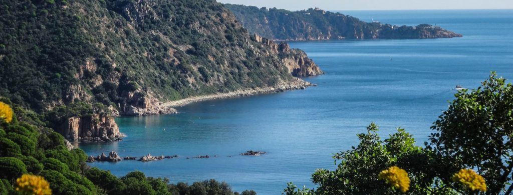
A quick 45-minute drive from the quickly growing European cycling hub, Girona, this windy, dramatic, roller coaster of a ride along the iconic Costa Brava between the small beach towns of S’Agaro and Tossa de Mar is a jaw dropping Mediterranean experience.
The extremely well kept road cruises along the coastal cliffs above the shockingly turquoise water where it is not uncommon to see sailboats, dolphins and divers enjoying the warm water will leave you with a sense of wonder while on your ride.
What you need to know
RIDE DETAILS Traffic on this road is usually fairly mellow but can get tight with all the quick hairpin turns and narrow sections. Make sure to keep your eyes up and look out for larger vehicles that may be taking up most of the road. The 5km climb to Ermita de Sant Grau d’Ardenya takes you 300m above the coastal road for an even more incredible view of the sea. 1378m total elevation gain, which may seem like a lot in such a short distance but, you won’t feel it as much as you think due to the undulating flow of the ride.
WEATHER The wind can be absolutely vicious on this ride during the winter and spring months due to what the Spaniards call “tramontana”, meaning “from the mountains,” this wind comes straight from the Pyrenees ready to blow you off your bike. It is recommended to leave the areo, tri bikes and deep dish wheels at home unless you find a thrill in getting tossed around.
FUEL While it feels fairly remote out here, you will never be far more than 15k from water refills or a huge plate of Paella. There are loads of restaurants and refueling options, shops and a 14th century fort to explore in Tossa de Mar.
While you’re in town
The closest large city, Girona, has an abundance of bike shops. We have our European headquarters in Girona, Trek Travel Cycling Center – Girona, for last minute gear needs or a bike rental.
For those with a taste for the finer things in life, stay at the Hostal de La Gavina in S’Agaro. This luxurious and historical castel-esque hotel is beautifully decorated with antiques while also maintaining a massive spa/ pool area, several dining options including a 5 course candlelight dinner by Michelin star chef, Romain Fornell and the most extensive breakfast buffet I’ve ever seen. The hotel also holds the accolade of being the only 5 star grand lux hotel in Catalonia.
Ready for this ride?
Book early and save. We reward our guests with lower pricing and more dates to choose from the earlier you book. Rest assured, once you book, your price is guaranteed.
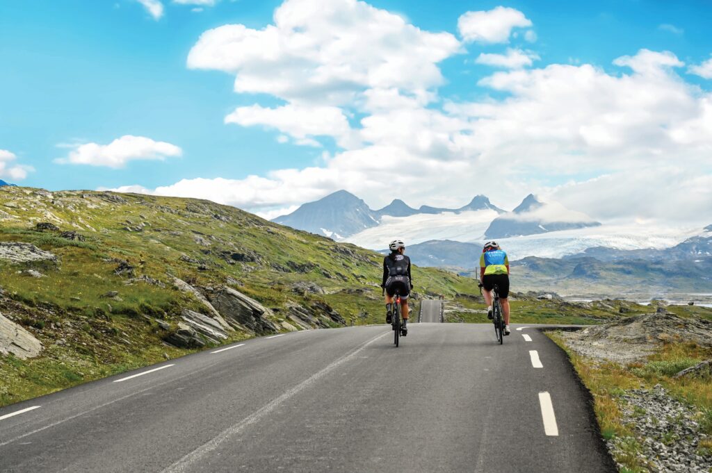
This iconic Northern Europe climb will test both your legs and your Gortex riding gear as it winds up from the small village of Skjolden up to the famous glaciers of Sognefjellet pass.
Only clear of snow a few months of the year, this relentless climb will offer incredible views of the vast and extremely remote mountainscape above the Fjords.
Designated, for good reason, as a Norwegian National Scenic route, you won’t regret testing the legs on this incredible, bucket list climb. Open May to mid August, the Sognefjellet ski center at 32.7kms, is a beautifully remodeled old ski lodge that offers tons of warm food options for lunch or a quick stop. It is not uncommon to see the Norwegian XC ski team training out on the glacier here during the summer.
What you need to know
Ride details: The 21.1 km climb crawls 1481m up from the Fjord to the highest mountain pass in Northern Europe. Average grade is 8.8% but don’t be surprised if you see grades as steep as 15%
rWeather: Due to the extreme environment of the far North, the weather changes incredibly fast here. Make sure to pack all the rain gear and a good attitude because you will likely need both.
Fuel: Water, coffee, assorted pastries and the best carrot cake you’ll ever have available at Turtagrø hotel 10km up the climb. They also have a big fireplace and lots of old mountaineering books to flip through while you warm up.
While you're in town
Stay at the Skjolden hotel right on the iconic Sognefjord, the largest and deepest fjord in Norway and only 5km from the base of the climb. The owner, Siri, of the Skjolden hotel is a great resource for the best hikes, rentals or various fjord adventures. You can almost always count on her being behind the front desk with a huge smile on her face.
All your grocery needs can be met at markets in Skjolden and Gaupne. About an hour from Skjolden is the larger town of Sogndal with a large outdoor store, cell phone stores and more food options.
Ready for Sognefjellet Pass?
Book early and save. We reward our guests with lower pricing and more dates to choose from the earlier you book. Rest assured, once you book, your price is guaranteed.
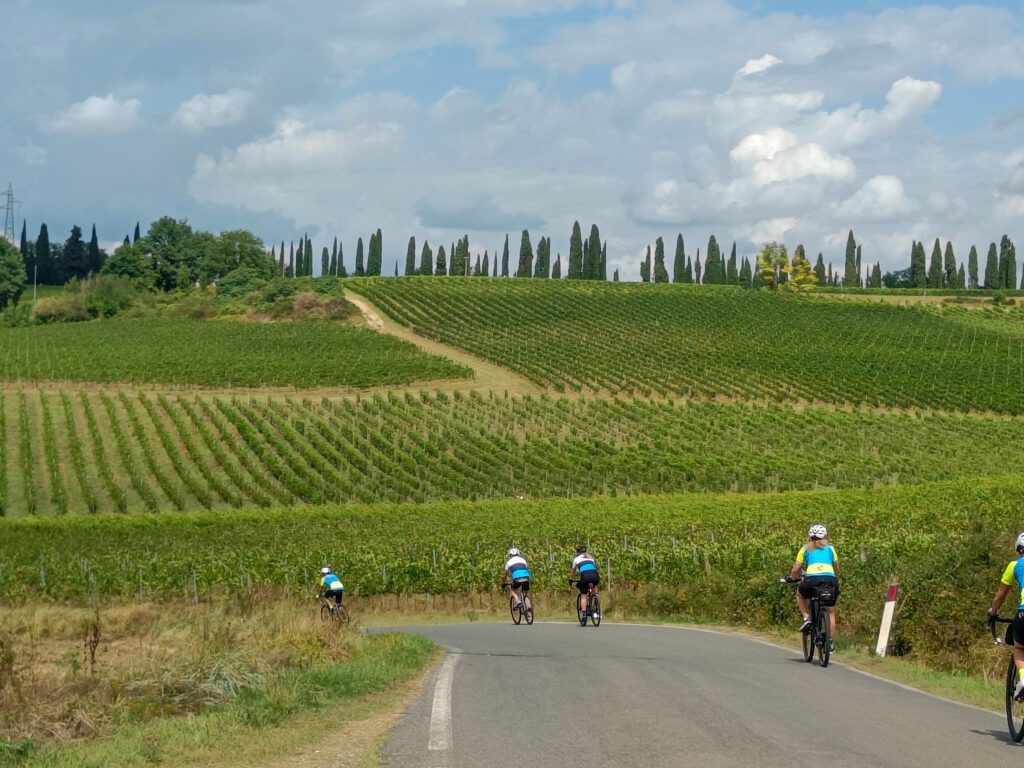
Tuscany is one of the places to cycle that people dream of. Ribbons of road carving through the mountains and hillsides, mountain tops dotted with quaint villages, world-renowned food, amazing wine, and Italian hospitality.
Location
Gaiole in Chianti, Tuscany, Italy
Distance
35 miles / 56.5km
Elevation Gain
3,819ft / 1,164m
Best Time to Visit
Spring or Fall
Surface
Paved Road
Difficulty
Level 3
Traffic
Level 1
Discover this ride on our Tuscany bike tour
Quintessential Luxury of Chianti’s Famous Castles and Wines
Today’s ride is a stunning loop from the village of Gaiole in Chianti heading out of the mountains and winding through the vineyards. Around 10km, the famed Castello di Brolio is just off our path. After passing the castle, the mountainous landscapes of Chianti give way to olive groves, vineyards, and gentle rolling roads snaking through the countryside. Around 30km into the ride, you will pass through Castelnuovo Berardenga, this is a great spot to refuel as you begin your ascent up Monteluco. The next 14.5km will take you to the top of today’s climb, which will average just over 3%. After ascending to the top, there is a little store to top up on water, and then you can enjoy the descent which will take you almost all the way back to our hotel.
What you need to know
RIDE DETAILS The first 25km of today’s ride is mostly downhill, averaging -0.1%. And different points of the ride, on a clear day, Sienna is off in the distance less then 20km away.
WEATHER Cycling in Chianti, the temperatures can be relatively cooler throughout the year, relative to those in Sienna. It is always wise to take layers with you, and prepare for the unexpected. Chianti seems to receive slightly more rain then some of the surrounding areas.
FUEL Great locations to refuel on the ride, 10.2km there is a cafe and the Enoteca of The Castello di Brolio. The next recommended stop for food and water is just before the 30km mark in Castelnuovo Berardenga. The final spot is on top of Monteluco at 44.2km.
While you’re in town
The village of Radda in Chainti is just 11km away. For those looking to explore another quaint village with fantastic wines and restaurants, it is worth a stop. Bar Dante is a great place to sit and sip a drink, while meandering through the village you will find great cycling shops, and Enoteca’s.
If you have a desire to cycle the White Roads on a vintage bike, simply stop in to La Bottegga and talk to Emanuele Nepi (he is one of the owners). He will be able to help you find a vintage bike to rent, along with getting you in the vintage gear.
Siena is only 25km away, and it is well worth the trip. From exploring the Duomo di Siena, Tower of Mangia, and the Piazza del Campo are highly recommended. The La Bottega dei Sapori Antichi is a great spot to grab a sandwhich to go, while GROM – Il Gelato come una volta & Gelateria Kopakabana are our favorite spots for Gelato.
Ready for this ride?
Book early and save. We reward our guests with lower pricing and more dates to choose from the earlier you book. Rest assured, once you book, your price is guaranteed.
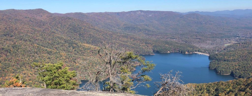
Caesar’s Head is a favorite ride of George Hincapie, a retired professional cyclist and local Greenville resident and a must ride if you are in South Carolina.
According to Hincapie, this ride “is one of the hardest climbs in the area.” and he often used it to gauge his fitness as he prepared for his 17-Tour de France participations.
The first 4-miles of the climb has a good steady gradient followed by a short reprieve, finishing with a steeper 2-miles section to the summit. The reward for conquering this challenging climb comes from the overlook at the summit of Caesar’s Head State Park, featuring breathtaking views of Table Rock State Park and the Blue Ridge Mountains. Keep a watchful eye out for some pro cyclists and junior development squads training in the early spring.
What you need to know
Ride details The climb has pretty well maintained pavement and light traffic for most of the year. Traffic increases with the arrival of the fall foliage in October which attracts lots of folks who come to see the dramatic colored leaves in this massive deciduous forest. The top of the climb is at about mile 33, but you climbing isn’t over yet. While the climb up to Ceasars Head summit is the toughest climb, you’ll still have 64 miles and about 4,000ft left to ride to get back to Greenville, unless you choose to do the ride as an out and back.
Weather Spring and Fall are definitely the best times tackle Caesar’s Head. Much of the climb is in a canopy of trees which offers good protection from the summer sun but it can get incredibly humid in the summer. Late spring and early fall you will get more variable weather but more comfortable humidity and less traffic. It is generally at least 10 degrees cooler at the summit, so make sure to pack layers.
Fuel The Mountain House Restaurant just before the summit is a great place to refuel for lunch featuring sandwiches, salads, ice cream and homemade fudge. The visitor center at the top has coffee, water and snacks available, along with a fireplace to warm up before the descent on colder days.
While you’re in town
There are tons of bike shops in Greenville which off bike rentals and plenty of gear to prepare you for the Ceasars head ride! Aside from excellent road biking, Greenville boast a plethora of other activities. Hike one of the hundreds of trails in surrounding state parks, white water rafting, waterfall tours or horse back riding. Greenville truly has it all!
Greenville is quickly becoming known as a “foodie” paradise. There are over 600 restaurants in Greenville (yes, 600!) with an enticing and diverse collection of dining experiences and cuisines ranging from traditional, to global, to downright eclectic.
Ready for Caesar's Head?
Book early and save. We reward our guests with lower pricing and more dates to choose from the earlier you book. Rest assured, once you book, your price is guaranteed.
If a date is marked as Private, it is reserved for a private group.
Looking to travel with a small group or looking for a custom date? Call our trip consultants at 866-464-8735
What is the Difference?
Ultimate Luxury:
Savor some of the most spectacular, 5-star properties in the world. Exuding luxury and elegance, these one-of-a-kind accommodations offer the chance to rejuvenate at award-winning spas, dine at Michelin-starred restaurants, and more.
Luxury:
Enjoy luxurious accommodations handpicked for a refined experience. From signature spa treatments to delicious local cuisine, you’ll be more than provided for; you’ll be pampered.
Explorer
These handpicked hotels provide relaxation and fun in a casual and comfortable environment. Delicious cuisine and great service mix perfectly for a memorable stay.
Combined
On select cycling vacations, you’ll stay at a mix of hotel levels, from Explorer to Luxury to Ultimate Luxury. Rest assured, no matter which level of hotel you’re at, our trip designers carefully select every accommodation.
Road: 1-3 hours of riding. Up to 25 mi (40 km). Up to 1,000 ft (300 m).
Gravel: 1-3 hours of riding. Up to 20 mi (35 km). Up to 1,000 ft (300 m).
Hiking: 1-3 hours of hiking. Up to 5 mi (8 km). Up to 1,000 ft (300 m).
Level 2:
Road: 2-4 hours of riding. 20-35 mi (35-60 km). Up to 2,500 ft (750 m).
Gravel: 2-4 hours of riding. 15-30 mi (25-45 km). Up to 2,000 ft (300 m).
Hiking: 2-4 hours of hiking. 4-8 mi (6-12 km). Up to 1,500 ft (450 m).
Level 3:
Road: 3-5 hours of riding. 25-55 mi (40-85 km). Up to 4,500 ft (1,500 m).
Gravel: 3-5 hours of riding. 20-40 mi (35-60 km). Up to 3,000 ft (900 m).
Hiking: 3-5 hours of hiking. 6-10 mi (9-16 km). Up to 2,000 ft (600 m).
Level 4:
Road: 4+ hours of riding. 40-70 mi (60-110 km). Up to 8,000 ft (2,400 m).
Gravel: 4+ hours of riding. 30-50 mi (45-80 km). Up to 4,000 ft (1,200 m).
Hiking: 4+ hours of hiking. 7-15 mi (11-24 km). Up to 4,000 ft (1,200 m).
What are your trip styles?
Classic - Reserve:
Savor the finer things as you relax in luxurious 5-star accommodations and wine, dine, and ride in some of the most unforgettable destinations around the world.
Classic - Signature:
Explore beautiful destinations by bike, enjoy extra inclusions, savor delicious local cuisine, and enjoy the perfect mix of accommodations.
Classic - Discover:
Enjoy a casual cycling vacation with fantastic routes and comfortable accommodations.
Ride Camp:
Train like the pros in some of their favorite riding destinations.
Pro Race:
See the pros in action at the biggest cycling events of the year.
Cross Country:
Tackle an epic adventure that takes you point-to-point across mountains, countryside, and more.
Self-Guided
Enjoy a bike tour on your schedule with just your chosen travel companions.
Sometimes it’s more convenient and comfortable to have your own room while on vacation. We understand and that’s why we offer a Single Occupancy option. The additional price guarantees a private room all to yourself
This website uses cookies to ensure you get the best experience on our website.